History
Vignacourt has a long history and was known as a market town in medieval times. This may be due to the following reasons:
- the regional impact of fairs and markets. The establishment of these open-air markets dates from the Middle Ages, with the support of the local lords in addition to the agreement of the king.
- the wide range of trades related to sales. Many dwellers were shopkeepers of flax, fabrics, hats, cattle, poultry, oil, flour, etc., including the itinerant merchants known as far as Paris.
- the variety of store sign names. The company names were linked to the name of the owner or to more specific designations such as «Comptoir français, Café de la Mairie, and Café du Progrès.
Shopkeepers and artisans remain quite diversified nowadays; furthermore, the flea market welcomes a significant number of visitors every year in May.
- Etymology
- Vine growing
- Blazon
- The castle
- Wayside crosses
- Windmills
- Water points
- The first maps
- The ancient roads
Etymology
According to previous research, the origins of the name Vignacourt could come from the name of a Roman chief or be linked to wine-growing.
The chief's name was Vinard Curtius; however, there is little evidence to support this theory. The meaning of the Vignacourt name could be related to the vines, with the prefix 'Vigna' in Latin for the vine, followed by the suffix "Curtis" in the sense of courtyard, a closed place.
Several street names included the word vines, such as the path of the vines, under the vines, and up of the vines. This is still the case today, to a lesser extent. Other municipalities had vineyards in the vicinity; however, the surface area occupied in the village was quite large.
The spelling of the name followed the evolution of the spoken language; more than ten different ways of writing have been identified, such as Wignacourt, Winardicurt, Vinardicuria, and Vinacourt on the Cassini map.

The grapevine in Vignacourt
Vine growing
The vineyard had grown in the region in the Middle Ages. The surface area of the land was large owing to the space needed for the rows of vines. The pruning had to be carried out to obtain a uniform distribution of the branches around the vine arms. The plot cultivation was done with the help of animal traction.
The decline of grapevines began in 1323 due to harsh winters and profitability issues. Nonetheless, the work of the vineyard continued for several more decades. The vintage wasn't outstanding, but it wasn't a verjuice either. The verjuice was initially made with sour herbs, for instance, sorrel. Since the 16th century, this preparation has been made in France with cheaper grapes than sorrel, which has the particularity of not fully ripening.

Animal traction on the hillsides of Bollenberg in Alsace in the East of France,
Photo courtesy of Domaine Valentin-Zusslin. ©
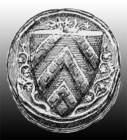
The counter-seal of the "Dreux d'Amiens" Lord
was adorned, with vine shoots, on the left or the right,
Photo « Source gallica.bnf.fr / BnF ».
The blazon
The coats of arms date back to the first knights, whose aim was to be easily identified. It was vital to quickly recognize your enemy on the battlefield. To choose their blazon, they had to respect several criteria, like the choice of colors according to their native regions.
The blazons were employed later by guilds, cities, and villages. The Wignacourt family coat of arms has three lilies won by hard victory on the battlefields. The fleur-de-lys is a symbol of the French monarchy, too. This template was included in the village blazon.
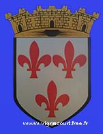
The blazon of Vignacourt.
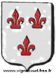
The Wignacourt coat of arms.
The first maps
The Cassini map
The Cassini map provides accurate details about the French kingdom. The distances were calculated 30 years before the French Revolution by César-François Cassini and Jean-Dominique Cassini. This typographic exercise was carried out with the unit of length, called "toise" in French; this metric unit was equivalent to 6 feet in French. The churches, mills, and wooded areas were specified.
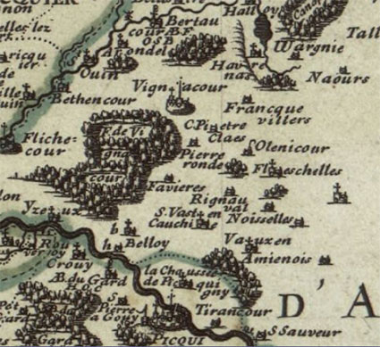
Vignacourt had been written without the letter G on the map; the church was drawn by a cross, just like a windmill, which is quite well represented. A thick line demarcated the Roman road called Brunehaut, which crossed the forest.
Vinacourt map «Source gallica.bnf.fr / BnF».
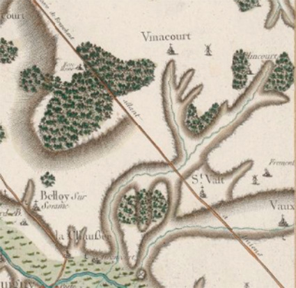
The Sanson map
Mr. Nicolas Sanson, born in Abbeville, was a cartographer. Richelieu, as well as other monarchs, praised his work for its attention to detail.
On the map below from 1656, Vignacourt is symbolized by two crosses, one for the church and one for the seigniorial castle, and the forest has been carefully drawn. Flixecourt, like Picquigny, had similar characteristics, both linked to the seigneury.
Vignacour map «Source gallica.bnf.fr / BnF».
The windmills
Millers Street testifies to the presence of mills, as evidenced by the the path to the burnt mill. On Stone Mill Street, the mill operated with a stone millstone. (It is not written with one S for Stone Street in the French version.) In the early 1910s, several mills still existed. The new milling methods caused its progressive disappearance.
The pole fixed to the roof allowed the miller to move the wings to benefit from a wind favorable to the rotation, as in the photo below. Cereals milled in these mills came from local crops.
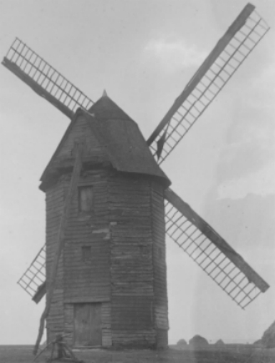
Ancient disappeared windmill.
The feudal Castle
The castle, a stone's throw from the collegiate church, was located on the castle's street. Old documents specified the importance of these constructions, surrounded by thatched cottages intended to house canons.
The Lord had to defend the interests of the country on the battlefield.
He regularly visited his properties to monitor and assume his obligations, although these were managed by a local administrator.

Castle Street.
The ancient roads
The Roman roads constituted a network of ancient roads that crossed France. The Chaussée Brunehaut (pavement) was a network of roads in the north of France, some of which connected Belgium, Luxembourg, and Germany.
This old network, according to experts, cannot be traced perfectly. However, the main routes are known as Utrecht in the Netherlands, Tournay in Belgium, and Cologne in Germany, as well as Amiens, Boulogne-sur-Mer, Reims, and Soissons, among others.
Roman roads were first built for the movement of troops and then became strategic trade routes. Some portions of this roadway are still visible to the south of the territory, towards St-Vaast-en-chaussée. They were once made of an assembly of several strata: a mixture of sand and lime, stones, pebbles, and a layer of cobblestones at the level of the coating.
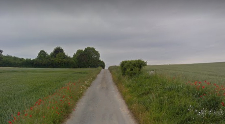
Brunehaut Way, a one-way path.
The wayside crosses
Wayside crosses placed at crossroads served as orientation and later became religious symbols. Military terminals, with distance indications engraved on the stone, were employed on ancient Roman roads. In the neighboring departments, oratories and small chapels served as landmarks.
These wayside shrines were erected high on a natural slope or built for this purpose. They were positioned at the intersection of the streets around the locality.
one of the wayside crosses.
Water points
The ponds, distributed mainly along the central street, served as drinking troughs for the cattle. The one known as the Grand Flot was located in the centre of the village, at the intersection of several streets.
The number of water points was more important in the past because they used to collect runoff water at a time when pipes did not yet exist. Several ponds have been backfilled, and the edges have been secured and reinforced with barriers for those that remain. Our elders had taken care of this place, using suitable plants to strengthen the banks.
The wells protected by tiles were quite numerous in the village before the arrival of tap water. The water was drawn up using a bucket with a long chain and was used, for instance, to cook food.